BOWFELL, CRINKLE CRAGS AND GLARAMARA.
|
There are some fells
that appeal on sight and become firm favourites with walkers over the years.
One of these which has a shapeliness and individuality few others can match
let alone surpass must be Bowfell. It's sharp summit is as rugged as they
come; the ultimate point a great pile of rocks and boulders across which
visitors have over the years scratched a few routes to the cairn. Bowfell
also boasts some fine crags which many people fail to look for as they cross
the top. To appreciate these properly the Climbers Traverse should be taken
from the path on The Band, and at the prominent waterspout turn sharp left up
the side of the Great Slab of Flat Crags. This feature is unique, and to miss
it on any walk on Bowfell would be a sin, as a simple tiny detour on the
final part of the ascent from Three Tarns gives a remarkable view from the
top across the face to Bowfell Buttress. The view from the summit has great
depth too and includes vistas of three valleys, Great Langdale, Eskdale and
the Duddon, while part of Langstrath is also seen. Crinkle Crags to the south
also provides dramatic situations above Langdale, and it's ridge deserves a
leisurely appreciation. The two fells form a great barrier between Eskdale
and Langdale, and only at the Wrynose Pass to the south is there some
relenting to allow a way through for a road. Disputing the claim for the
finest ridge hereabouts is that from Esk Hause over Allen Crags and Glaramara
which finally falls to Borrowdale above Rosthwaite. Many delightful tarns
adorn the ridge, and between Glaramara and Bessyboot near Tarn at Leaves,
despite some very fine scenery, the paths are still in places not easy to
follow in mist, and relative peace still reigns here. Another important
member of this section refuses to be overshaddowed by the greater fells
nearby. Climb Pike O'Blisco and most walkers will feel they have had to work
hard to get there. The summit rocks command a grand view down to Great
Langdale, while the eastern aspect of Crinkle Crags is most impressive from
here. I must not forget Esk Pike lying between Bowfell and the Scafells. It
has some fine colourful rocks, and a south ridge falling to Eskdale that is a
reminder of what Lakeland was like years ago. Those who find these fells
tedious are strongly advised to take up another pastime, for here to most
walkers the hills and the scenery are that bit special.
|
|
|
|
|
----------------
|
ROUTE ONE. BOWFELL FROM GREAT LANGDALE VIA ROSSETT
PIKE.
4.75 miles 2900ft of ascent. 3.25 miles 1825ft of ascent to Rossett
Pike.
|
|
|
|
click to enlarge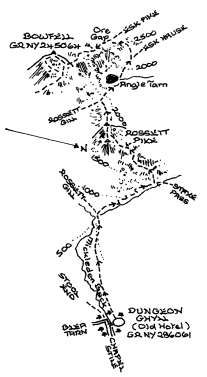
|
From the
Old Hotel at the head of Great Langdale take the track along the Mickleden
valley, and turn up the path to the Stake Pass. Keep to the zig zags
faithfully until the gradient begins to ease. Just before the path crosses
the stream go up a path on the left which is cairned in part, but needs
careful attention as it traverses the steep fellside. It emerges on the ridge
at Littlegill Head yet retains it's own identity above the Mickleden face to
the summit of Rossett Pike. Now descend to Angle Tarn and a short way up the
facing slope take the left branch which is the path to Ore Gap between Esk
Pike and Bowfell. Esk Pike can be added to the walk by going up right from
Ore Gap, or better though longer by continuing up the main track from Angle
Tarn to Esk Hause. Particularly if Bowfell has been climbed directly from Ore
Gap then the best route down would be to Three Tarns, and traversing the
Crinkle Crags ridge to Red Tarn turning down the path into Oxendale. If
energy is lacking then at Three Tarns bear left and go down The Band to Stool
End.
|
|
----------------
|
ROUTE TWO. BOWFELL
FROM GREAT LANGDALE VIA PIKE O'BLISCO, COLD PIKE AND CRINKLE CRAGS.
6.5 miles 4550ft of ascent.
|
Ascent Breakdown
|
Distance
|
Ascent
|
|
miles
|
km
|
ft
|
metres
|
|
Old Hotel to Blake Rigg.
|
1.75
|
2.8
|
1450
|
442
|
|
Blake Rigg to Pike O?Blisco
|
1
|
1.6
|
650
|
198
|
|
Pike O'Blisco to Cold Pike.
|
1
|
1.6
|
650
|
198
|
|
Cold Pike to Crinkle Crags.
|
1.5
|
2.4
|
950
|
290
|
|
Crinkle Crags to Bowfell.
|
1.25
|
2
|
850
|
259
|
|
|
|
|
click to enlarge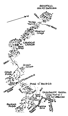
|
This walk can of course
be shortened and the ascent cut by omitting Pike O'Blisco and Cold Pike which
is what many people do. There is a considerable ascent involved, but if a
short route down from Bowfell is then taken the distance is not excessive.
From the Old Hotel walk along the road to Blea Tarn, but turn into the camp
site and locate a stile on the right. This leads to more stiles then a steady
ascent to the summit of the road. Across the road the popular path round Blea
Tarn passes through a stile, but go ahead up the fell picking up a path which
becomes clearer in time. It winds up the slope through a small shallow gully
before going steeply up to join the better known route by Redacre Gill. If
Blake Rigg is to be included it can be ascended anywhere over ?the slopes to the south east from this
point. The path is now all too clear, and with some easy rock scrambling can
be followed up to Pike O'Blisco. Descend to Red Tarn south west and proceed
ahead up the stony trail towards Crinkle Crags. If it is desired to visit
Cold Pike this can be done by turning up a much nicer path where the main
track crosses the stream below Great Knott. There is now a path that goes
westwards from Cold Pike and curves up to rejoin the usual route below the
first Crinkle. Either way the scenery changes dramatically at this point, and
the path will not be lost in clear weather. The Bad Step on the ascent of the
highest and second Crinkle can be avoided by going round on the left. Long
legs are a distinct asset in places like this! If the Crinkles havn't been
stony enough then complete the walk to Bowfell by ascending the bouldery path
above Three Tarns. The most direct way down is via The Band from Three Tarns,
but the best and not much longer is to go down by the side of the Great Slab
to the waterspout, and turn right onto the Climbers Traverse so joining The
Band lower down. If all the walk has been done it will have been a grand day
out!
|
|
----------------
|
ROUTE
THREE. BOWFELL FROM COCKLEY BECK VIA LITTLE STAND AND
CRINKLE
CRAGS.
4.5miles 3175ft of ascent.
|
Ascent Breakdown
|
Distance
|
Ascent
|
|
miles
|
km
|
ft
|
metres
|
|
Cockley Beck to Little Stand
|
2
|
3.2
|
1800
|
549
|
|
Little Stand to Crinkle Crags
|
1.25
|
2
|
525
|
160
|
|
Crinkle Crags to Bowfell
|
1.25
|
2
|
850
|
259
|
|
|
|
|
click to enlarge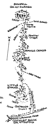
|
Over the bridge at Cockley
Beck there might be a problem if the stream is in spate in getting onto the
north bank of the River Duddon. Assuming this has been done proceed along what was
once the Roman Road and tum up to the ruins of Gaitscale Farm. Above the
intake wall stile a path bravely heads up through the bracken but fades in the
grasslands higher up. With Gaitscale Gill on the right continue the toil to the
head of the stream and curve round left onto the ridge north of Little Stand. The summit is
a good one with plenty of low crags and grand little tarns. Retum along the ridge
where beyond the next rise an electric fence is met and a stile has been provided.
Ahead now are the rocky tops of Crinkle Crags, and as in Route Two beyond the first
Crinkle, if the Bad Step looks one step too far avoid it by circling round the rockface
on the left to the main summit. The other tops which are adjacent to the path may be
visited along the ridge which is everywhere stony. An oasis of grass at Three
Tarns is succeeded by a bouldery scramble up to Bowfell's equally rocky summit.
To return to Cockley Beck
consider either descending to Three Tarns where tum right on the Eskdale path,
or join it 1ower down by taking the ridge path to Esk Pike, and at Ore Gap going down
left to Green Hole. Cross the low saddle by Swinsty Gill into Mosedale which leads
directly if rather marshy down to the farm.
|
|
----------------
|
ROUTE FOUR. BOWFELL FROM ESKDALE
(Brotherilkeld) VIA THROSTLEHOW CRAG AND ESK PIKE.
6 miles 315Oft of ascent.
|
Ascent Breakdown
|
Distance
|
Ascent
|
|
miles
|
km
|
ft
|
metres
|
|
Brotherilkeld to Throstlehow Crag
|
3
|
4.8
|
1000
|
305
|
|
Throstlehow Crag to Esk Pike
|
2
|
3.2
|
1750
|
533
|
|
Esk Pike to Bowfell.
|
1
|
1.6
|
400
|
122
|
|
|
|
|
click to enlarge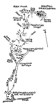
|
Follow the track up the
valley from Brotherilkeld Farm all the way to Lingcove Bridge a fine example of
it's kind. Cross the bridge and continue upstream by Esk Falls to the point where
the river bends sharp left below the cliffs of Scar Lathing. Here tum up right on a
narrow path that climbs to the ridge behind Throstlehow Crag which is easily
attained from this point. Return to the col and work round the right side of the
prominent Long Crag to gain Esk Pike's south ridge as it begins to
take shape. This
ridge is yet a fine example of what all Lakeland walking used to be
like. The path is
still rather vague at times, but it hardly matters if the ridge is
retained. Pristine
conditions persist all the way to the summit where the scarred highway from Esk Hause to
Bowfell is met. From Esk Pike a wide stony trail drops down to Ore Gap before
rounding Hanging Knotts up to Bowfell. Hanging Knotts makes an interesting
detour, and don't on any account miss the view across the face from the gully by Bowfell
Buttress. The descent is best achieved by the path to
Three Tarns where tum right for Lingcove Beck.
|
|
----------------
|
ROUTE
FIVE. ALLEN CRAGS FROM BORROWDALE (Stonethwaite) VIA
ROSTHWAITE
FELL, ROSTHWAITE CAM, COMB HEAD AND GLARAMARA.
5 miles 3100ft of ascent
|
Ascent Breakdown
|
Distance
|
Ascent
|
|
miles
|
km
|
ft
|
metres
|
|
Stonethwaite to Rosthwaite Fell.
|
1.5
|
2.4
|
1500
|
457
|
|
Rosthwaite Fell to Rosthwaite Cam.
|
0.5
|
0.8
|
350
|
107
|
|
Rosthwaite Cam to Comb Head.
|
1
|
1.6
|
500
|
152
|
|
Comb Head to Glaramara.
|
0.5
|
0.8
|
250
|
76
|
|
Glaramara to Allen Crags.
|
1.5
|
2.4
|
500
|
152
|
|
|
|
|
click to enlarge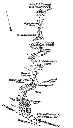
|
The ascent starts about a
third of a mile out of Stonethwaite along the track to Langstrath. A gate gives
entry to the path climbing up the left side of Great (Big) Stanger Gill. This path has
thankfully been repaired, but is still a challenge as it steeply makes it's way up
and into a little gorge before curving round to the right and cresting the slope.
Follow the path to the head of the gill where a series of ridges
come down on the
left. These days the summit ridge is obvious as the path makes it's way to it, but at one
time this was a confusing place. The caim on Bessyboot is considered as the summit
of Rosthwaite Fell though in fact this is the lower part of the fell. Go down to Tarn
at Leaves which I have always thought a lovely place, and ascend the path up the
facing slope to the prominent rocky peak of Rosthwaite Cam. The top is reached by an
easy scramble and has a grand view down Borrowdale. The ridge path now crosses
over to the Langstrath side of the ridge losing a little height
on occasion, and
climbing in stages before turning back west to cross Comb Door. A
steep climb leads
onto Comb Head though the path actually skirts the top crossing
the final grassy
plateau before a second rocky ascent is required to the actual summit of Glaramara. Walkers
who are tiring and assuming Comb Head to be the top will be disappointed
as they see another significant climb ahead. Glaramara has more than one top too
before the ridge descends to lower levels still undulating and always demanding
underfoot. Watch out for several delightful small tarns; the best
being just beyond
High House Tarn tucked away on the left in a rocky surround. The ground begins to rise
to Allen Crags after this, and the trials and delights this ridge provides in tum are
over. Even
the descent cannot be taken lightly as after going down to Esk Hause by the
wall shelter the
choice is either descending Grains Gill to Seathwaite, and there
taking the field
path to Thorneythwaite and Mountain View; or walking the full length of Langstrath after
descent from Angle Tarn.
|
|
Copyright (C) 2007 B S Baker
����������������������������������������������������������������������������������������������������������������������������������������������������������������������������������������������������������������������������������������������������������������������������������������������������������������������������������������������������������������������������������������������������������������������������������������������������������������������������������������������������������������������������������������������������������������������������������������������������������������������������������������������������������������������������������������������������������������������������������������������������������������������������������������������������������������������������������������������������������������������������������������������������������������������������������������������������������������������������������������������������������������������������������������������������������������������������������������������������������������������������������������������������������������������������������������������������������������������������������������������������������������������������������������������������������������������������������������������������������������������������������������������������������������������������������������������������������������������������������������������������������������������������������������������������������������������������������������������������������������������������������������������������������������������������������������������������������������������������������������������������������������������������������������������������������������������������������������������������������������������������������������������������������������������������������������������������������������������������������������������������������������������������������������������������������������������������������������������������������������������������������������������������������������������������������������������������������������������������������������������������������������������������������������������������������������������������������������������������������������������������������������������������������������������������������������������������������������������������������������������������������������������������������������������������������������������������������������������������������������������������������������������������������������������������������������������������������������������������������������������������������������������������������������������������������������������������������������������������������������������������������������������������������������������������������������������������������������������������������������������������������������������������������������������������������������������������������������������������������������������������������������������������������������������������������������������������������������������������������������������������������������������������������������������������������������������������������������������������������������������������������������������������������������������������������������������������������������������������������������������������������������������������������������������������������������������������������������������������������������������������������������������������������������������������������������������������������������������������������������������������������������������������������������������������������������������������������������������������������������������������������������������������������������������������������������������������������������������������������������������������������������������������������������������������������������������������������������������������������������������������������������������������������������������������������������������������������������������������������������������������������������������������������������������������������������������������������������������������������������������������������������������������������������������������������������������������������������������������������������������������������������������������������������������������������������������������������������������������������������������������������������������������������������������������������������������������������������������������������������������������������������������������������������������������������������������������������������������������������������������������������������������������������������������������������������������������������������������������������������������������������������������������������������������������������������������������������������������������������������������������������������������������������������������������������������������������������������������������������������������������������������������������������������������������������������������������������������������������������������������������������������������������������������������������������������������������������������������������������������������������������������������������������������������������������������������������������������������������������������������������������������������������������������������������������������������������������������������������������������������������������������������������������������������������������������������������������������������������������������������������������������������������������������������������������������������������������������������������������������������������������������������������������������������������������������������������������������������������������������������������������������������������������������������������������������������������������������������������������������������������������������������������������������������������������������������������������������������������������������������������������������������������������������������������������������������������������������������������������������������������������������������������������������������������������������������������������������������������������������������������������������������������������������������������������������������������������������������������������������������������������������������������������������������������������������������������������������������������������������������������������������������������������������������������������������������������������������������������������������������������������������������������������������������������������������������������������������������������������������������������������������������������������������������������������������������������������������������������������������������������������������������������������������������������������������������������������������������������������������������������������������������������������������������������������������������������������������������������������������������������������������������������������������������������������������������������������������������������������������������������������������������������������������������������������������������������������������������������������������������������������������������������������������������������������������������������������������������������������������������������������������������������������������������������������������������������������������������������������������������������������������������������������������������������������������������������������������������������������������������������������������������������������������������������������������������������������������������������������������������������������������������������������������������������������������������������������������������������������������������������������������������������������������������������������������������������������������������������������������������������������������������������������������������������������������������������������������������������������������������������������������������������������������������������������������������������������������������������������������������������������������������������������������������������������������������������������������������������������������������������������������������������������������������������������������������������������������������������������������������������������������������������������������������������������������������������������������������������������������������������������������������������������������������������������������������������������������������������������������������������������������������������������������������������������������������������������������������������������������������������������������������������������������������������������������������������������������������������������������������������������������������������������������������������������������������������������������������������������������������������������������������������������������������������������������������������������������������������������������������������������������������������������������������������������������������������������������������������������������������������������������������������������������������������������������������������������������������������������������������������������������������������������������������������������������������������������������������������������������������������������������������������������������������������������������������������������������������������������������������������������������������������������������������������������������������������������������������������������������������������������������������������������������������������������������������������������������������������������������������������������������������������������������������������������������������������������������������������������������������������������������������������������������������������������������������������������������������������������������������������������������������������������������������������������������������������������������������������������������������������������������������������������������������������������������������������������������������������������������������������������������������������������������������������������������������������������������������������������������������������������������������������������������������������������������������������������������������������������������������������������������������������������������������������������������������������������������������������������������������������������������������������������������������������������������������������������������������������������������������������������������������������������������������������������������������������������������������������������������������������������������������������������������������������������������������������������������������������������������������������������������������������������������������������������������������������������������������������������������������������������������������������������������������������������������������������������������������������������������������������������������������������������������������������������������������������������������������������������������������������������������������������������������������������������������������������������������������������������������������������������������������������������������������������������������������������������������������������������������������������������������������������������������������������������������������������������������������������������������������������������������������������������������������������������������������������������������������������������������������������������������������������������������������������������������������������������������������������������������������������������������������������������������������������������������������������������������������������������������������������������������������������������������������������������������������������������������������������������������������������������������������������������������������������������������������������������������������������������������������������������������������������������������������������������������������������������������������������������������������������������������������������������������������������������������������������������������������������������������������������������������������������������������������������������������������������������������������������������������������������������������������������������������������������������������������������������������������������������������������������������������������������������������������������������������������������������������������������������������������������������������������������������������������������������������������������������������������������������������������������������������������������������������������������������������������������������������������������������������������������������������������������������������������������������������������������������������������������������������������������������������������������������������������������������������������������������������������������������������������������������������������������������������������������������������������������������������������������������������������������������������������������������������������������������������������������������������������������������������������������������������������������������������������������������������������������������������������������������������������������������������������������������������������������������������������������������������������������������������������������������������������������������������������������������������������������������������������������������������������������������������������������������������������������������������������������������������������������������������������������������������������������������������������������������������������������������������������������������������������������������������������������������������������������������������������������������������������������������������������������������������������������������������������������������������������������������������������������������������������������������������������������������������������������������������������������������������������������������������������������������������������������������������������������������������������������������������������������������������������������������������������������������������������������������������������������������������������������������������������������������������������������������������������������������������������������������������������������������������������������������������������������������������������������������������������������������������������������������������������������������������������������������������������������������������������������������������������������������������������������������������������������������������������������������������������������������������������������������������������������������������������������������������������������������������������������������������������������������������������������������������������������������������������������������������������������������������������������������������������������������������������������������������������������������������������������������������������������������������������������������������������������������������������������������������������������������������������������������������������������������������������������������������������������������������������������������������������������������������������������������������������������������������������������������������������������������������������������������������������������������������������������������������������������������������������������������������������������������������������������������������������������������������������������������������������������������������������������������������������������������������������������������������������������������������������������������������������������������������������������������������������������������������������������������������������������������������������������������������������������������������������������������������������������������������������������������������������������������������������������������������������������������������������������������������������������������������������������������������������������������������������������������������������������������������������������������������������������������������������������������������������������������������������������������������������������������������������������������������������������������������������������������������������������������������������������������������������������������������������������������������������������������������������������������������������������������������������������������������������������������������������������������������������������������������������������������������������������������������������������������������������������������������������������������������������������������������������������������������������������������������������������������������������������������������������������������������������������������������������������������������������������������������������������������������������������������������������������������������������������������������������������������������������������������������������������������������������������������������������������������������������������������������������������������������������������������������������������������������������������������������������������������������������������������������������������������������������������������������������������������������������������������������������������������������������������������������������������������������������������������������������������������������������������������������������������������������������������������������������������������������������������������������������������������������������������������������������������������������������������������������������������������������������������������������������������������������������������������������������������������������������������������������������������������������������������������������������������������������������������������������������������������������������������������������������������������������������������������������������������������������������������������������������������������������������������������������������������������������������������������������������������������������������������������������������������������������������������������������������������������������������������������������������������������������������������������������������������������������������������������������������������������������������������������������������������������������������������������������������������������������������������������������������������������������������������������������������������������������������������������������������������������������������������������������������������������������������������������������������������������������������������������������������������������������������������������������������������������������������������������������������������������������������������������������������������������������������������������������������������������������������������������������������������������������������������������������������������������������������������������������������������������������������������������������������������������������������������������������������������������������������������������������������������������������������������������������������������������������������������������������������������������������������������������������������������������������������������������������������������������������������������������������������������������������������������������������������������������������������������������������������������������������������������������������������������������������������������������������������������������������������������������������������������������������������������������������������������������������������������������������������������������������������������������������������������������������������������������������������������������������������������������������������������������������������������������������������������������������������������������������������������������������������������������������������������������������������������������������������������������������������������������������������������������������������������������������������������������������������������������������������������������������������������������������������������������������������������������������������������������������������������������������������������������������������������������������������������������������������������������������������������������������������������������������������������������������������������������������������������������������������������������������������������������������������������������������������������������������������������������������������������������������������������������������������������������������������������������������������������������������������������������������������������������������������������������������������������������������������������������������������������������������������������������������������������������������������������������������������������������������������������������������������������������������������������������������������������������������������������������������������������������������������������������������������������������������������������������������������������������������������������������������������������������������������������������������������������������������������������������������������������������������������������������������������������������������������������������������������������������������������������������������������������������������������������������������������������������������������������������������������������������������������������������������������������������������������������������������������������������������������������������������������������������������������������������������������������������������������������������������������������������������������������������������������������������������������������������������������������������������������������������������������������������������������������������������������������������������������������������������������������������������������������������������������������������������������������������������������������������������������������������������������������������������������������������������������������������������������������������������������������������������������������������������������������������������������������������������������������������������������������������������������������������������������������������������������������������������������������������������������������������������������������������������������������������������������������������������������������������������������������������������������������������������������������������������������������������������������������������������������������������������������������������������������������������������������������������������������������������������������������������������������������������������������������������������������������������������������������������������������������������������������������������������������������������������������������������������������������������������������������������������������������������������������������������������������������������������������������������������������������������������������������������������������������������������������������������������������������������������������������������������������������������������������������������������������������������������������������������������������������������������������������������������������������������������������������������������������������������������������������������������������������������������������������������������������������������������������������������������������������������������������������������������������������������������������������������������������������������������������������������������������������������������������������������������������������������������������������������������������������������������������������������������������������������������������������������������������������������������������������������������������������������������������������������������������������������������������������������������������������������������������������������������������������������������������������������������������������������������������������������������������������������������������������������������������������������������������������������������������������������������������������������������������������������������������������������������������������������������������������������������������������������������������������������������������������������������������������������������������������������������������������������������������������������������������������������������������������������������������������������������������������������������������������������������������������������������������������������������������������������������������������������������������������������������������������������������������������������������������������������������������������������������������������������������������������������������������������������������������������������������������������������������������������������������������������������������������������������������������������������������������������������������������������������������������������������������������������������������������������������������������������������������������������������������������������������������������������������������������������������������������������������������������������������������������������������������������������������������������������������������������������������������������������������������������������������������������������������������������������������������������������������������������������������������������������������������������������������������������������������������������������������������������������������������������������������������������������������������������������������������������������������������������������������������������������������������������������������������������������������������������������������������������������������������������������������������������������������������������������������������������������������������������������������������������������������������������������������������������������������������������������������������������������������������������������������������������������������������������������������������������������������������������������������������������������������������������������������������������������������������������������������������������������������������������������������������������������������������������������������������������������������������������������������������������������������������������������������������������������������������������������������������������������������������������������������������������������������������������������������������������������������������������������������������������������������������������������������������������������������������������������������������������������������������������������������������������������������������������������������������������������������������������������������������������������������������������������������������������������������������������������������������������������������������������������������������������������������������������������������������������������������������������������������������������������������������������������������������������������������������������������������������������������������������������������������������������������������������������������������������������������������������������������������������������������������������������������������������������������������������������������������������������������������������������������������������������������������������������������������������������������������������������������������������������������������������������������������������������������������������������������������������������������������������������������������������������������������������������������������������������������������������������������������������������������������������������������������������������������������������������������������������������������������������������������������������������������������������������������������������������������������������������������������������������������������������������������������������������������������������������������������������������������������������������������������������������������������������������������������������������������������������������������������������������������������������������������������������������������������������������������������������������������������������������������������������������������������������������������������������������������������������������������������������������������������������������������������������������������������������������������������������������������������������������������������������������������������������������������������������������������������������������������������������������������������������������������������������������������������������������������������������������������������������������������������������������������������������������������������������������������������������������������������������������������������������������������������������������������������������������������������������������������������������������������������������������������������������������������������������������������������������������������������������������������������������������������������������������������������������������������������������������������������������������������������������������������������������������������������������������������������������������������������������������������������������������������������������������������������������������������������������������������������������������������������������������������������������������������������������������������������������������������������������������������������������������������������������������������������������������������������������������������������������������������������������������������������������������������������������������������������������������������������������������������������������������������������������������������������������������������������������������������������������������������������������������������������������������������������������������������������������������������������������������������������������������������������������������������������������������������������������������������������������������������������������������������������������������������������������������������������������������������������������������������������������������������������������������������������������������������������������������������������������������������������������������������������������������������������������������������������������������������������������������������������������������������������������������������������������������������������������������������������������������������������������������������������������������������������������������������������������������������������������������������������������������������������������������������������������������������������������������������������������������������������������������������������������������������������������������������������������������������������������������������������������������������������������������������������������������������������������������������������������������������������������������������������������������������������������������������������������������������������������������������������������������������������������������������������������������������������������������������������������������������������������������������������������������������������������������������������������������������������������������������������������������������������������������������������������������������������������������������������������������������������������������������������������������������������������������������������������������������������������������������������������������������������������������������������������������������������������������������������������������������������������������������������������������������������������������������������������������������������������������������������������������������������������������������������������������������������������������������������������������������������������������������������������������������������������������������������������������������������������������������������������������������������������������������������������������������������������������������������������������������������������������������������������������������������������������������������������������������������������������������������������������������������������������������������������������������������������������������������������������������������������������������������������������������������������������������������������������������������������������������������������������������������������������������������������������������������������������������������������������������������������������������������������������������������������������������������������������������������������������������������������������������������������������������������������������������������������������������������������������������������������������������������������������������������������������������������������������������������������������������������������������������������������������������������������������������������������������������������������������������������������������������������������������������������������������������������������������������������������������������������������������������������������������������������������������������������������������������������������������������������������������������������������������������������������������������������������������������������������������������������������������������������������������������������������������������������������������������������������������������������������������������������������������������������������������������������������������������������������������������������������������������������������������������������������������������������������������������������������������������������������������������������������������������������������������������������������������������������������������������������������������������������������������������������������������������������������������������������������������������������������������������������������������������������������������������������������������������������������������������������������������������������������������������������������������������������������������������������������������������������������������������������������������������������������������������������������������������������������������������������������������������������������������������������������������������������������������������������������������������������������������������������������������������������������������������������������������������������������������������������������������������������������������������������������������������������������������������������������������������������������������������������������������������������������������������������������������������������������������������������������������������������������������������������������������������������������������������������������������������������������������������������������������������������������������������������������������������������������������������������������������������������������������������������������������������������������������������������������������������������������������������������������������������������������������������������������������������������������������������������������������������������������������������������������������������������������������������������������������������������������������������������������������������������������������������������������������������������������������������������������������������������������������������������������������������������������������������������������������������������������������������������������������������������������������������������������������������������������������������������������������������������������������������������������������������������������������������������������������������������������������������������������������������������������������������������������������������������������������������������������������������������������������������������������������������������������������������������������������������������������������������������������������������������������������������������������������������������������������������������������������������������������������������������������������������������������������������������������������������������������������������������������������������������������������������������������������������������������������������������������������������������������������������������������������������������������������������������������������������������������������������������������������������������������������������������������������������������������������������������������������������������������������������������������������������������������������������������������������������������������������������������������������������������������������������������������������������������������������������������������������������������������������������������������������������������������������������������������������������������������������������������������������������������������������������������������������������������������������������������������������������������������������������������������������������������������������������������������������������������������������������������������������������������������������������������������������������������������������������������������������������������������������������������������������������������������������������������������������������������������������������������������������������������������������������������������������������������������������������������������������������������������������������������������������������������������������������������������������������������������������������������������������������������������������������������������������������������������������������������������������������������������������������������������������������������������������������������������������������������������������������������������������������������������������������������������������������������������������������������������������������������������������������������������������������������������������������������������������������������������������������������������������������������������������������������������������������������������������������������������������������������������������������������������������������������������������������������������������������������������������������������������������������������������������������������������������������������������������������������������������������������������������������������������������������������������������������������������������������������������������������������������������������������������������������������������������������������������������������������������������������������������������������������������������������������������������������������������������������������������������������������������������������������������������������������������������������������������������������������������������������������������������������������������������������������������������������������������������������������������������������������������������������������������������������������������������������������������������������������������������������������������������������������������������������������������������������������������������������������������������������������������������������������������������������������������������������������������������������������������������������������������������������������������������������������������������������������������������������������������������������������������������������������������������������������������������������������������������������������������������������������������������������������������������������������������������������������������������������������������������������������������������������������������������������������������������������������������������������������������������������������������������������������������������������������������������������������������������������������������������������������������������������������������������������������������������������������������������������������������������������������������������������������������������������������������������������������������������������������������������������������������������������������������������������������������������������������������������������������������������������������������������������������������������������������������������������������������������������������������������������������������������������������������������������������������������������������������������������������������������������������������������������������������������������������������������������������������������������������������������������������������������������������������������������������������������������������������������������������������������������������������������������������������������������������������������������������������������������������������������������������������������������������������������������������������������������������������������������������������������������������������������������������������������������������������������������������������������������������������������������������������������������������������������������������������������������������������������������������������������������������������������������������������������������������������������������������������������������������������������������������������������������������������������������������������������������������������������������������������������������������������������������������������������������������������������������������������������������������������������������������������������������������������������������������������������������������������������������������������������������������������������������������������������������������������������������������������������������������������������������������������������������������������������������������������������������������������������������������������������������������������������������������������������������������������������������������������������������������������������������������������������������������������������������������������������������������������������������������������������������������������������������������������������������������������������������������������������������������������������������������������������������������������������������������������������������������������������������������������������������������������������������������������������������������������������������������������������������������������������������������������������������������������������������������������������������������������������������������������������������������������������������������������������������������������������������������������������������������������������������������������������������������������������������������������������������������������������������������������������������������������������������������������������������������������������������������������������������������������������������������������������������������������������������������������������������������������������������������������������������������������������������������������������������������������������������������������������������������������������������������������������������������������������������������������������������������������������������������������������������������������������������������������������������������������������������������������������������������������������������������������������������������������������������������������������������������������������������������������������������������������������������������������������������������������������������������������������������������������������������������������������������������������������������������������������������������������������������������������������������������������������������������������������������������������������������������������������������������������������������������������������������������������������������������������������������������������������������������������������������������������������������������������������������������������������������������������������������������������������������������������������������������������������������������������������������������������������������������������������������������������������������������������������������������������������������������������������������������������������������������������������������������������������������������������������������������������������������������������������������������������������������������������������������������������������������������������������������������������������������������������������������������������������������������������������������������������������������������������������������������������������������������������������������������������������������������������������������������������������������������������������������������������������������������������������������������������������������������������������������������������������������������������������������������������������������������������������������������������������������������������������������������������������������������������������������������������������������������������������������������������������������������������������������������������������������������������������������������������������������������������������������������������������������������������������������������������������������������������������������������������������������������������������������������������������������������������������������������������������������������������������������������������������������������������������������������������������������������������������������������������������������������������������������������������������������������������������������������������������������������������������������������������������������������������������������������������������������������������������������������������������������������������������������������������������������������������������������������������������������������������������������������������������������������������������������������������������������������������������������������������������������������������������������������������������������������������������������������������������������������������������������������������������������������������������������������������������������������������������������������������������������������������������������������������������������������������������������������������������������������������������������������������������������������������������������������������������������������������������������������������������������������������������������������������������������������������������������������������������������������������������������������������������������������������������������������������������������������������������������������������������������������������������������������������������������������������������������������������������������������������������������������������������������������������������������������������������������������������������������������������������������������������������������������������������������������������������������������������������������������������������������������������������������������������������������������������������������������������������������������������������������������������������������������������������������������������������������������������������������������������������������������������������������������������������������������������������������������������������������������������������������������������������������������������������������������������������������������������������������������������������������������������������������������������������������������������������������������������������������������������������������������������������������������������������������������������������������������������������������������������������������������������������������������������������������������������������������������������������������������������������������������������������������������������������������������������������������������������������������������������������������������������������������������������������������������������������������������������������������������������������������������������������������������������������������������������������������������������������������������������������������������������������������������������������������������������������������������������������������������������������������������������������������������������������������������������������������������������������������������������������������������������������������������������������������������������������������������������������������������������������������������������������������������������������������������������������������������������������������������������������������������������������������������������������������������������������������������������������������������������������������������������������������������������������������������������������������������������������������������������������������������������������������������������������������������������������������������������������������������������������������������������������������������������������������������������������������������������������������������������������������������������������������������������������������������������������������������������������������������������������������������������������������������������������������������������������������������������������������������������������������������������������������������������������������������������������������������������������������������������������������������������������������������������������������������������������������������������������������������������������������������������������������������������������������������������������������������������������������������������������������������������������������������������������������������������������������������������������������������������������������������������������������������������������������������������������������������������������������������������������������������������������������������������������������������������������������������������������������������������������������������������������������������������������������������������������������������������������������������������������������������������������������������������������������������������������������������������������������������������������������������������������������������������������������������������������������������������������������������������������������������������������������������������������������������������������������������������������������������������������������������������������������������������������������������������������������������������������������������������������������������������������������������������������������������������������������������������������������������������������������������������������������������������������������������������������������������������������������������������������������������������������������������������������������������������������������������������������������������������������������������������������������������������������������������������������������������������������������������������������������������������������������������������������������������������������������������������������������������������������������������������������������������������������������������������������������������������������������������������������������������������������������������������������������������������������������������������������������������������������������������������������������������������������������������������������������������������������������������������������������������������������������������������������������������������������������������������������������������������������������������������������������������������������������������������������������������������������������������������������������������������������������������������������������������������������������������������������������������������������������������������������������������������������������������������������������������������������������������������������������������������������������������������������������������������������������������������������������������������������������������������������������������������������������������������������������������������������������������������������������������������������������������������������������������������������������������������������������������������������������������������������������������������������������������������������������������������������������������������������������������������������������������������������������������������������������������������������������������������������������������������������������������������������������������������������������������������������������������������������������������������������������������������������������������������������������������������������������������������������������������������������������������������������������������������������������������������������������������������������������������������������������������������������������������������������������������������������������������������������������������������������������������������������������������������������������������������������������������������������������������������������������������������������������������������������������������������������������������������������������������������������������������������������������������������������������������������������������������������������������������������������������������������������������������������������������������������������������������������������������������������������������������������������������������������������������������������������������������������������������������������������������������������������������������������������������������������������������������������������������������������������������������������������������������������������������������������������������������������������������������������������������������������������������������������������������������������������������������������������������������������������������������������������������������������������������������������������������������������������������������������������������������������������������������������������������������������������������������������������������������������������������������������������������������������������������������������������������������������������������������������������������������������������������������������������������������������������������������������������������������������������������������������������������������������������������������������������������������������������������������������������������������������������������������������������������������������������������������������������������������������������������������������������������������������������������������������������������������������������������������������������������������������������������������������������������������������������������������������������������������������������������������������������������������������������������������������������������������������������������������������������������������������������������������������������������������������